
Page 6 - Georgia Forestry - Summer 2017
P. 6
INNOVATION
BIRDSEYEVIEW AEROBOTICS
A Bird’s Eye View
Drone technology is the latest innovation impacting the management of forestland
Newly developed technologies in unmanned aircraft systems (UAS), more commonly referred to as
drones, are revolutionizing the way that foresters and landowners are conducting silvicultural activities. Projects that once required tenuous boots-on-the-ground activity or manned aircraft can now be accomplished in a timely and cost- effective manner.
So what does it do? The basic functions of drone technology allow forest manag- ers to capture up-to-date aerial data for mapping purposes. The most common benefit for landowners has come in the form of calculating and plotting harvested acres. Prior to this new technology, a for- ester would cover the harvest boundary by foot with a GPS unit and provide the results to a GIS technician. From there, the technician would incorporate the data into client maps. Now, that process is much easier.
F&W Forestry Services currently has five offices with drone pilots and will have a drone pilot in every office by 2018. According to Stephen Logan, Forest Technology Manager with F&W Forestry
Services, drone technology has served as a tool to support internal forest operations activity and better communicate with absentee landowners.
“It has allowed us to cut down tremen- dously on the field time associated with labor intensive mapping projects, decreas- ing the time spent plotting GPS coordinates by nearly 400 percent in some instances,” Logan said. “It has also given us the oppor- tunity to provide 3D models of tracts to clients so they can view their property without leaving their home or office.” �
MATT HESTAD IS A PUBLIC RELATIONS AND COMMUNICATIONS PROFESSIONAL KEENLY FOCUSED ON COMMUNICATING THE BENEFITS OF WORKING FORESTS, AGRICULTURE AND NATURAL RESOURCES.
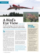
The BirdsEyeView Firefly6, pictured above, is a fixed-wing drone that can take off and land vertically and then cover large forest areas. Video and imagery captured by drones can provide forest managers with a quick look at damage from forest pests disease, such as pine beetles shown in inset image.
Who Can FlyaDrone?
New regulations from the Federal Aviation Administration (FAA) require a drone certification process for low-risk commercial UAS f lights. Individuals can become certified to operate
UAS aircraft by meeting certain conditions, including:
� Pass an initial aeronautical
test and retesting every two years;
� Pass a background check
by the Transportation Security Administration;
� Be at least 16 years old;
� Make the UAS and any required documentation available for inspection by the FAA; and
� Report any accident that
results in injury or property damage greater than $500 to the FAA within 10 days.
Individuals may still fly model air- craft under a recreational status, but some guidelines still apply. To ensure that you are operating your drone within the law, visit www.knowbeforeyoufly.com.
4 | GEORGIA FORESTRY
by Matt Hestad
F&W FORESTRY SERVICES, INC.
